 Getting more of our children to walk and bike to school improves child and community health, benefits the environment by reducing automobile emissions, and decreases traffic congestion around schools. To support these efforts, Safe Moves, in partnership with the City of Mountain View and supported by a grant from VERBS (Santa Clara County’s Vehicle Emissions Reductions Based at Schools program), created these Recommended Routes to School maps for public schools attended by Mountain View residents. To create the maps Safe Moves walked and biked every possible route to school.
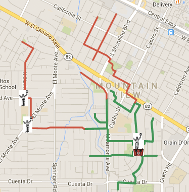
Please check your child’s recommended route to school and leave a comment with your suggestions for how to improve safety or send us an email. When using the maps, note that green lines are recommended routes that are less than .5 miles long. Red lines are routes that are more than .5 miles long.
Elementary Schools
- Benjamin Bubb Elementary School
- Edith Landels Elementary School
- Frank L. Huff Elementary School
- Mariano Castro Elementary School
- Monta Loma Elementary School
- Springer Elementary School
- Stevenson Elementary School
- Theuerkauf Elementary School
Middle Schools
High Schools
Los Altos Schools
Los Altos has also developed Suggested Routes to School including maps for Almond, Egan, Blach, Covington, Loyola, Oak, Montclaire, Bullis, Springer, and Santa Rita. Maps include routes within Los Altos borders.
For Graham Middle School, the only crossing for El Camino is at Castro St. It’s unsafe to ride a bike along the commercial section of Castro Street because there is not a shoulder for bikes and there is alot of auto and pedestrian activity during morning rush hour. The City should strive to create a safer route that enables crossing ECR at Shoreline.
What do the red vs green route lines indicate?
Hi Janet: Green lines indicate recommended for walk and walk. Orange lines indicate recommended for bike.
The intersection of Central and Rengstorff, where my kids have to bike to High School at Los Altos is far from great. As a matter of fact it is just about the worst intersection where kids have to cross on the entire peninsula. Somebody’s kid is going to die there. I guess we are waiting until that happens to fix it? How can you be recommending this 6 way intersection with grade level train going through, Heavy traffic and tons of pedestrians, kids on bikes and insane backups as a Great bike route.
Hi Becky: Agreed that Rengstorff and Central is a terrible intersection! The fact that Safe Moves determined that intersection to be the safest route for getting to Los Altos High says a lot about how lacking our infrastructure is for biking. The City is currently kicking off a Bicycle Transportation plan which will establish the network of bike lanes and boulevards in the City. I encourage you to sign-up for the Great Streets Mountain View newsletter if you want to stay informed about this process and learn more about how to have input.
There is no mention of St. Joseph Elementary School located on Miramonte. Over 200 children attend school there.
Private schools like St. Joseph’s usually have a lot of students who come from farther away (unlike public schools which have designated attendance areas where almost all their students live). It’s probably not cost-effective for Safe Moves to evaluate routes to all the private schools in MV, since they don’t know how many students even live within biking or walking distance of them.
The maps used by Safe Moves do not show all the bike paths. Two of the high school routes can be improved by using bike paths that are not on the Safe Moves maps, but are on Google Maps.
LAHS:
The northernmost section along El Camino Real can be avoided by taking the brand new bike path that connects Monroe Drive to the end of Cesano Court. This allows cyclists to cross straight across El Camino at a stoplight, which is safer than trying to bike along El Camino.
MVHS:
The recommended route from the Eagle Park area is rather roundabout. A more direct route is:
Church –> Calderon –> cross El Camino –> continue on Phyllis –> cross
Grant –> continue on Martens –> path from Martens to Yorkshire –>
Sleeper –> Franklin, then continue on the Safe Moves route.